GSH will
- Use advanced satellite assets as Copernicus Sentinels, Copernicus Contributing Missions (CCM), LEO Cubesats/Smallsats, and
- Further develop AI-based algorithms for object detection on satellite and UAV images
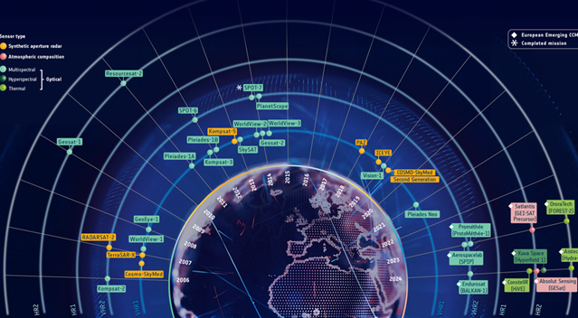
Advanced satellite assets as Copernicus Contributing missions (CCM), LEO Cubesats/Smallsats with tasking capabilities
- Optical data (visible, NIR, SWIR), Hyperspectral, TIR
- SAR data (day/ night, all weather)
- Spatial resolution: <1m to several m
- Revisit: daily or more frequent
- CCM data either public (CNES, DLR, ESA) or commercial (Pléiades, WorldView, RapidEye, etc)
- Cubesats data either public (ESA, National Programs) or commercial (Planet, BlackSky, etc)
- Easy download from multiple platforms or portals and process in relevant s/w
Main capabilities of the technology:
- Automatic object detection and classification on satellite/ UAV data or video
- Change detection using multitemporal imagery
- Processing of VHR data as CCM, LEO Cubesats/Smallsats or UAV data
- Processing of multi-spectral and multi-modal data
- Unusual objects detection
- Real time and off line detection
- Integration and mapping in GIS
- Technology can be used in mobile installation in BF mobile C2 platform.