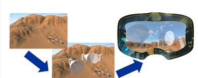
AIT will develop a MR module for mission planning to visualize the setup and its coverage of areas. Users can plan e.g., where cameras are placed or where drones have to fly to cover a certain area. For visualizing data in the right location, the user’s location has to be known at all times through a location algorithm combined with a map of the covered area.
Using Mixed Reality users will be able to visualize surveillance setups and their coverage by overlaying virtual representations of cameras over the physical world while taking into account the locations of physical objects.
Current Capabilities
- Mixed reality is usable in the field
- Mixed reality allows for more intuitive planning (and training)
- Mixed reality can visualize areas that are not covered by surveillance
- Mixed reality could visualize movement of camera coverage and drone paths in real-time