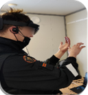
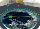
The mobile XR-based C2/tactical commander tool for situation awareness, which includes XR components in a headset. The C2 or tactical commander will monitor a 3D map of the area, interacting with real-time XR elements like movable observation towers, alarms, sensor data, UxV videos, camera streams, and other tactical information. The module will also record and display past data for assessing situations based on historical trends.
Enhanced shared situation awareness includes:
- Multi-user feature, enabling several users to join the same XR environment with different devices, fostering collaboration and strategic planning.
- Shared displays of information to ensure all team members have access to critical data for comprehensive situation awareness and informed decision-making.
- Profile-based data layers, where information is tailored based on user profile or rank, ensuring relevant data is available to the right personnel.
- Recording and playback of the situation, clarifying which information is saved to the server, such as UxV positions and sensor data, for thorough post-event analysis and training.
- Upgrade of the latest XR devices and support for multi-device use, ensuring compatibility and optimized performance across various technological platforms.
- Task or profile-based selection of displayed information, allowing users to focus on the most pertinent data for their specific roles and responsibilities.

Main capabilities
- Mobile XR solution: The mobile XR system is designed to provide tactical commander with advanced situation awareness through immersive technology, enhancing their ability to make timely and informed decisions.
- 3D map data in XR: The headset displays a comprehensive 3D map of the area, integrating various data points and enabling real-time interaction with XR elements such as observation towers, UxV and sensor data.
- Several assets’ data: The system aggregates data from multiple assets including UxV locations, sensor information, patrol metadata, camera streams, and other geo-located resources.
- UxV: Location, sensor data, stream: This feature allows users to view and analyze UxV positions, sensor readings, and live video streams to gain a better understanding of the current operational environment.
- Patrols: Location, meta-data: Patrol data includes location tracking and metadata, providing detailed insights into movement patterns and operational status.
- Camera streams: Potential limitation of supported stream formats: While the system supports various camera streams, there may be limitations regarding the formats supported by Unity3D.
- Other geo-located data: Also, alerts, pictures, annotations,….: The system incorporates geo-located alerts, pictures, and annotations, facilitating comprehensive situation awareness and historical analysis.
- User-based data layers: Information is tailored to user profiles or ranks, ensuring that relevant data is accessible to the appropriate personnel for effective decision-making.